

BOM issues weather warning for ‘strongest weather system this winter’
Get ready Australia because the mercury is about to drop as the country faces its most severe weather system this year in the next 72 hours.
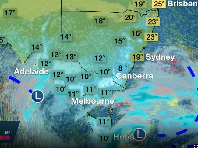
Millions of people in Australia have been warned to “prepare now” as an icy Antarctic blast sweeps up from the south today.
The “strongest weather system this winter” will bring high winds, cold temperatures, sleet and snow from today until Sunday.
The Bureau of Meteorology has issued a range of warnings across New South Wales, South Australia and Victoria because of the cold front.
“This could be the strongest cold outbreak so far this winter,” the Bureau of Meteorology’s Michael Logan said.
“We’ll see temperatures really plummet and snow levels down to 500 metres in Victoria and NSW and blizzard conditions in Alpine areas.
“It certainly is a real cold snap, now is the time to prepare.”
The polar weather could reach as far north as southern Queensland with snow flurries in the Granite Belt and Tablelands and damaging winds for Sydney and the South Coast.
Forecasters have warned of “bitter” temperatures as the mercury plummets at a rate of knots.
Temperatures are not expected to rise again until mid next week.

A weakening in high pressure systems has finally allowed cooler air from Antarctica to reach into southern Australia. Picture: Sky News WeatherSource:Supplied
In NSW there is a severe weather warning for damaging winds across the Illawarra, Snowy Mountains and parts of the South Coast and Central Tablelands.
Winds gusts are expected in excess of 90km/hour with showers and thunderstorms in places.
The NSW National Parks and Wildlife Service has recommended back country travel be postponed, with skifield regions affected including Thredbo Top, Nowra, Bowral, Wollongong, Katoomba, Cooma, Braidwood, Wentworth and Deniliquin.
The front will be the most severe this year, the BOM has said.Source:Supplied
Damaging winds are also forecast in South Australia for Adelaide, the Mount Lofty Ranges and Yorke Peninsula among other areas as a vigorous cold front moves through.
Wind gusts are expected to reach 110km/hour before easing overnight. Adelaide will have the strongest winds and rain from midday to the early evening.
In Victoria, high winds are expected across the alpine region with gusts of up to 110km/hour and blizzard conditions from dawn on Thursday through to Friday morning.
Locations which may be affected include Mildura, Horsham, Warrnambool, Bendigo, Shepparton, Seymour, Ballarat, Geelong, Melbourne, Traralgon, Mt Baw Baw, Mt Buller, Mt Hotham and Falls Creek.
WHY IS IT GETTING SO COLD?
Unusually warm temperatures has been a feature of Winter 2019 in Australia. In an average winter, cooler air from the Antarctic pushes into southern Australia bringing down the mercury and serving up wind and rain.
However, stubborn areas of high pressure have, for months, acted as a barrier to this polar air which has been unable to push very far into the mainland at all.
High pressure brings settled conditions and clear skies. In winter, that means warm days with maximums ways above the average. For instance, in Sydney 17C is the usual winter daily high, but this year it’s been closer to 18C, while overnight lows are around three degrees warmer.
Clear skies also let that warm weather escape overnight which has led to lots of frost this year too.
But now, the high pressure appears to be losing its battle with the Antarctic conditions. It’s heading north to more tropical climes, allowing unsettled conditions and cloud to make an appearance in the south.
That will mean cooler days but, in some places, more average night time lows.